From fjords to icefields: why salmon glacier matters to ocean travelers
Many divers and marine travelers are surprised that a glacier can deepen their understanding of the sea. Standing before salmon glacier in northern British Columbia, you see the frozen source that ultimately feeds coastal fjords and rich salmon runs. This immense valley glacier located about 25 km north of Stewart offers a rare chance to connect mountain ice, river systems, and the Pacific Ocean in a single road based experience.
Salmon glacier stretches roughly 20 km through the Boundary Ranges, its crevasses and seracs forming a slow moving river of ice. Meltwater from the glacier salmon system flows toward the Portland Canal, influencing estuaries that nurture salmon populations and the marine food web. For divers who explore kelp forests and cold water reefs along the British Columbia coast, this high country landscape explains why those underwater ecosystems are so productive.
The Geographical Names Board of Canada officially named the glacier decades ago, recognizing its importance as a natural landmark. Today, salmon glacier is also a key stop on many a northern road trip that links inland hubs such as prince george and smithers with the coastal settlement of Stewart. Travelers often pair a day at the glacier viewpoint with time on the water near Prince Rupert or liveaboard itineraries along the Inside Passage, creating a holistic journey from ice to ocean.
Planning the road trip: routes, timing, and essential logistics
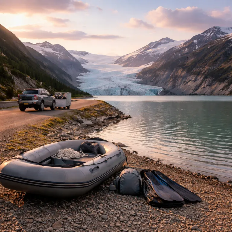
Reaching salmon glacier requires a commitment to the road and a respect for remote conditions. Most visitors follow the highway from prince george to smithers, then continue along the scenic route to stewart british Columbia near the alaska border. From Stewart, you cross the border into hyder alaska and follow a rough mountain road that climbs toward the glacier viewpoint above the main icefield.
This road trip rewards patience, because road conditions can shift quickly with rain, thaw, or late snow. Authorities recommend visiting between early July and late September, when the glacier located above the valley is most accessible and the annual ice dam break has usually stabilized river levels. Vehicles with decent clearance handle the gravel road better, and divers hauling gear for a wider coastal trip salmon itinerary should secure tanks and equipment against constant vibration.
There is no entry fee for salmon glacier ; self guided auto tours allow you to stop wherever the view salmon perspective is safe and compelling. “How can I access Salmon Glacier?” and “When is the best time to visit?” and “Is there an entry fee? No entry fee; self-guided tours available.” For those combining the journey with cold water diving, it is wise to schedule a rest day at Stewart or Hyder before any deep immersion. Use that time to review advanced breathing techniques for cold conditions, drawing on resources such as this guide to safer and more rewarding diving experiences.
Stewart, Hyder, and the marine corridor between ice and ocean
The twin communities of stewart and hyder form a small but strategic hub for glacier and marine travelers. Stewart British Columbia sits at the head of the Portland Canal, a long fjord that connects inland glaciers with Pacific waters rich in salmon and marine life. Just across the border, hyder alaska offers access to the gravel road that climbs past bear glacier and onward to the main salmon glacier viewpoint.
For divers, this corridor illustrates how freshwater from glacier salmon melt shapes coastal ecosystems. Nutrient laden rivers carry silt and minerals into the fjord, where tidal mixing supports plankton blooms that feed fish, seabirds, and marine mammals. Planning a trip salmon itinerary that includes both the glacier and a charter on the fjord allows you to see how the same water carves ice, nourishes forests, and eventually sustains kelp forests and rockfish offshore.
Stewart hyder also provides practical services that make the remote highway feel more manageable. Fuel, basic groceries, and simple lodgings cluster near the waterfront, while local operators share updates on road conditions and wildlife activity at fish creek and other viewing sites. Many marine travelers break the long drive from prince george or smithers with an overnight stay here, using the extra time to walk the tidal flats, watch the changing view salmon over the fjord, and prepare for the demanding road up to salmon glacier the following day.
Glacier viewpoints, fish creek bears, and ethical wildlife watching
The primary glacier viewpoint above salmon glacier offers one of the most expansive roadside views of ice in canada. From this high perch, the glacier located in the valley below curves away in a sweeping S shape, its surface fractured by deep blue crevasses. On clear days, the surrounding peaks of the Boundary Ranges frame the icefield, creating a scenic panorama that rivals more famous sites yet remains far less crowded.
On the drive up from hyder alaska, you pass bear glacier, which tumbles almost to the roadside and often reflects in a milky blue lake. This stretch of road is a highlight of any road trip through stewart hyder, but drivers must remain alert for washouts, potholes, and changing road conditions. Stopping only in designated pullouts protects fragile roadside vegetation and reduces the risk of blocking the narrow road for other vehicles making the same trip salmon journey.
Back near sea level, fish creek is renowned for its seasonal bear viewing, where brown and black bears feed on returning salmon in the shallow river. Elevated boardwalks keep visitors at a respectful distance, supporting both safety and wildlife welfare while still allowing a remarkable view salmon behavior in a natural setting. Divers and marine travelers who value responsible shark and ray encounters will recognize similar principles here, echoed in guidance such as this article on responsible encounters on the Great Barrier Reef.
Climate change, glacier retreat, and implications for coastal diving
Salmon glacier, like many glaciers in british Columbia, is retreating under the influence of climate change. As the glacier salmon mass shrinks, meltwater patterns shift, affecting river flow, sediment loads, and the timing of freshwater pulses into downstream fjords. For divers who frequent the British Columbia coast, these changes can alter visibility, plankton blooms, and even the distribution of cold adapted species over time.
Researchers have documented that the river below salmon glacier can rise several feet when seasonal ice dams release, reshaping channels that carry water toward the sea. Over decades, reduced ice volume may mean less summer meltwater, changing salinity gradients that are crucial for juvenile salmon and estuarine life. Marine travelers planning a recurring road trip to this region can witness these shifts firsthand, comparing the view salmon from the glacier viewpoint across multiple visits.
Climate aware itineraries increasingly link inland sites such as mount robson, various provincial park reserves, and coastal fjords into a single educational journey. Driving the highway between prince george, smithers, and stewart british Columbia, you pass rivers and wetlands that all connect back to the same hydrological story. By the time you reach the border crossing near hyder alaska and continue to the glacier located above the valley, the relationship between mountain ice, salmon runs, and ocean dive sites becomes a tangible narrative rather than an abstract concept.
Practical tips for marine focused travelers visiting salmon glacier
For divers and ocean enthusiasts, planning time at salmon glacier alongside coastal activities requires careful logistics. Start by mapping the highway route from prince george to smithers, then onward to stewart, allowing generous buffers for weather and road conditions. Many travelers allocate at least one full day for the glacier salmon area, plus additional days for fjord cruises or shore based exploration near the coast.
Vehicle preparation is essential, especially if your road trip includes heavy dive gear or camera housings. Check tires, brakes, and fluids before leaving larger centers such as george smithers, and carry a basic emergency kit with warm layers, water, and food. The road from hyder alaska to the glacier viewpoint is unpaved and can be rough, so secure cylinders and delicate housings to prevent damage during the drive and any sudden stops.
Because there is no formal gate at the border crossing between stewart and hyder, travelers sometimes underestimate the remoteness of the area. Always check the latest information from local tourism offices about access, seasonal closures, and wildlife advisories around fish creek and other sites. With thoughtful planning, your trip salmon itinerary can weave together the glacier, the scenic fjord, and future dives along the British Columbia coast into one coherent, memorable journey that highlights how intimately glaciers, salmon, and the sea are connected.
Key statistics about salmon glacier and its watershed
- Approximate length of salmon glacier: 20 km from its upper accumulation zone to the lower terminus.
- Typical seasonal river rise below the glacier during major melt or ice dam release events: around 4 feet.
- Optimal visiting window for road access and stable viewing conditions: from early July to late September.
- Driving distance from Stewart to the main glacier viewpoint: roughly 25 km along an unpaved mountain road.
Essential questions for planning a visit to salmon glacier
How can I access salmon glacier during a marine focused trip ?
Access to salmon glacier is via a mountain road that begins in hyder alaska, just across the border from stewart British Columbia. Most marine travelers first follow the highway from prince george to smithers, then continue to stewart before crossing the border and driving the gravel road to the glacier viewpoint. This route allows you to integrate inland ice, salmon rivers, and coastal fjords into a single, well structured itinerary.
When is the best time to combine glacier viewing with coastal diving ?
The most reliable period for visiting salmon glacier runs from early July to late September, when snow has receded from the road and visibility over the icefield is often at its best. This timing also aligns with peak marine life activity along much of the British Columbia coast, making it easier to schedule a road trip that includes both glacier viewing and cold water diving. By planning your days carefully, you can enjoy clear views of the glacier located in the Boundary Ranges and still have ample time for fjord cruises or shore dives.
Is salmon glacier suitable for a single day side trip from the coast ?
While it is technically possible to visit salmon glacier as a long day trip from coastal hubs, most travelers find that at least one overnight in stewart or hyder offers a more relaxed experience. The road conditions, variable weather, and sheer amount of scenery along the route reward a slower pace, especially if you are also managing dive gear or underwater camera systems. Treating the glacier salmon area as a dedicated segment of your journey, rather than a rushed detour, allows you to appreciate how this valley glacier, its salmon fed rivers, and the nearby ocean truly belong to the same interconnected system.
